After record-breaking warmth over the weekend, another winter storm is on the way. The potential exists for several inches of snow in parts of the state.A Winter Storm Watch has been issued for much of southern New Hampshire ahead of Tuesday’s storm.TIMINGA mild and dry Monday is in store, but snow is expected to break out after midnight and through the pre-dawn hours of Tuesday. The heaviest snow will fall during the morning and midday hours. Snow will taper off through Tuesday afternoon.>> National Weather Service alerts and bulletinsAMOUNTSAt this point, the heaviest snow looks to fall in far southern New Hampshire. 6-10 inches of accumulation are possible along the coast, through the lower Merrimack Valley, and into the Monadnock Region. >> Hour-by-hour of the snowFarther north, places like Rochester, Concord, and the Lakes Region could pick up 3-6 inches. Lighter snow totals are expected in the White Mountains and the Great North Woods.>> Download the free WMUR app to get updates on the go: Apple | Google Play <<IMPACTSTravel and school disruptions are expected in parts of New Hampshire, especially Tuesday morning. The snow that falls will be heavy and wet in many communities. While it will be tough to clean up, power outages are not expected to be an issue.>> Interactive radarAlong the coast, tides have been running astronomically high. Minor to moderate coastal flooding is possible during Tuesday’s high tide, right around 2:00 p.m.Stay with the Storm Watch 9 team for updates.Be weather-aware! Download the WMUR app for Apple or Android devices and turn on push notifications. You can choose to receive weather alerts for your geolocation and/or up to three ZIP codes. In addition, you can receive word when precipitation is coming to your area.Get storm coverage through the free Very Local app on your smart TV.Follow the Storm Watch 9 team on social media:Mike Haddad: Facebook | XKevin Skarupa: Facebook | XHayley LaPoint: Facebook | XJacqueline Thomas: Facebook | XMatt Hoenig: Facebook | X
After record-breaking warmth over the weekend, another winter storm is on the way. The potential exists for several inches of snow in parts of the state.
A Winter Storm Watch has been issued for much of southern New Hampshire ahead of Tuesday’s storm.
TIMING
A mild and dry Monday is in store, but snow is expected to break out after midnight and through the pre-dawn hours of Tuesday.
The heaviest snow will fall during the morning and midday hours. Snow will taper off through Tuesday afternoon.
>> National Weather Service alerts and bulletins
AMOUNTS
At this point, the heaviest snow looks to fall in far southern New Hampshire. 6-10 inches of accumulation are possible along the coast, through the lower Merrimack Valley, and into the Monadnock Region.
Farther north, places like Rochester, Concord, and the Lakes Region could pick up 3-6 inches. Lighter snow totals are expected in the White Mountains and the Great North Woods.
>> Download the free WMUR app to get updates on the go: Apple | Google Play <<
IMPACTS
Travel and school disruptions are expected in parts of New Hampshire, especially Tuesday morning. The snow that falls will be heavy and wet in many communities. While it will be tough to clean up, power outages are not expected to be an issue.
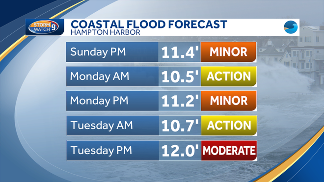
Along the coast, tides have been running astronomically high. Minor to moderate coastal flooding is possible during Tuesday’s high tide, right around 2:00 p.m.
Stay with the Storm Watch 9 team for updates.
Be weather-aware! Download the WMUR app for Apple or Android devices and turn on push notifications. You can choose to receive weather alerts for your geolocation and/or up to three ZIP codes. In addition, you can receive word when precipitation is coming to your area.
Get storm coverage through the free Very Local app on your smart TV.
Follow the Storm Watch 9 team on social media:


