
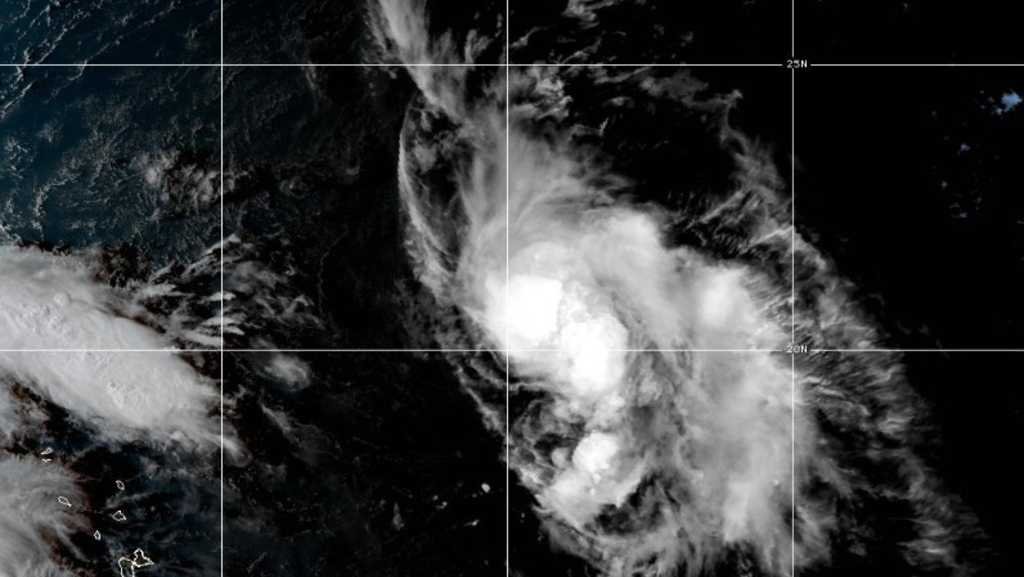
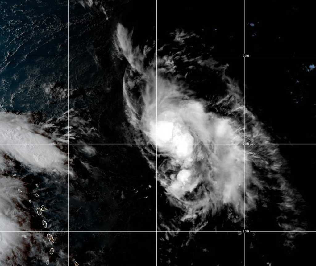
WITH SOME BREAKING WEATHER NEWS. WE’VE BEEN MONITORING THE TROPICS. WE’VE SEEN A LOT OF DEVELOPMENT. AND NOW WE HAVE HUMBERTO. THAT’S RIGHT. INVEST 93 WHICH IS RIGHT NOW ABOUT 500 MILES EAST OF THE LEEWARD ISLANDS, HAS OFFICIALLY BEEN UPGRADED TO TROPICAL STORM ALBERTO. SO LET’S TAKE A LOOK AT ITS LATEST STATS. WINDS OF 40MPH. MOVING WEST NORTHWEST AT 15 AGAIN ABOUT 500 MILES EAST OF THE LEEWARD ISLANDS. AND THANKFULLY, AS WE TAKE A LOOK AT ITS FORECAST TRACK AND CONE, IT’S NOT EXPECTED TO DIRECTLY IMPACT ANY LAND. SO THAT’S THE GOOD NEWS. YOU CAN SEE IT IS EXPECTED TO GRADUALLY INTENSIFIED TO A CATEGORY ONE HURRICANE BY THIS WEEKEND, THOUGH, AND THEN BY EARLY NEXT WEEK, STRENGTHENING TO A CATEGORY TWO STORM. SO THAT’S ALBERTO, WHICH JUST DEVELOPED. BUT WHAT WE’RE KEEPING CLOSE TABS ON IS THIS ONE. INVEST 94 L. THIS IS NEAR PUERTO RICO AS WE SPEAK, BRINGING HEAVY RAIN THERE TO NOT ONLY PUERTO RICO BUT ALSO THE DOMINICAN REPUBLIC. HERE’S A LOOK AT THE LATEST MODELS WITH INVEST 94 L. THE CONSENSUS IS THIS WILL CURVE OFF TO THE NORTH AND THEN NORTHEAST AS WE GO INTO LATE WEEK INTO THE UPCOMING WEEKEND. IT IS EXPECTED TO BECOME EITHER A TROPICAL DEPRESSION OR POSSIBLY EVEN A TROPICAL STORM BY THIS WEEKEND. WHERE IT’S GOING TO GO IS STILL TO BE DETERMINED. SO THESE MODELS ARE NOT CONCRETE. AND THAT IS BECAUSE 94 L COULD IMPACT OR ACTUALLY ROTATE OR GO UNDER WHAT’S CALLED A FUJIWHARA EFFECT. WITH ALBERTO. WHAT IS THE FUJIWHARA EFFECT? IT’S WHEN TWO TROPICAL CYCLONES. SO INVEST 94 AND ALSO ALBERTO ROTATE OR ORBIT AROUND A COMMON AXIS. SO BASICALLY WHAT THEY DO IS A LITTLE BIT OF A TROPICAL TANGO OR TROPICAL DANCE. TWO THINGS CAN EMERGE OUT OF THAT ONE. THE TWO TROPICAL SYSTEMS CAN ACTUALLY MERGE AND BECOME A BIGGER SYSTEM. OR THIRD, IT COULD ACTUALLY JUST ROTATE AND THEN CAUSE YOU TO REPEL AWAY FROM EACH OTHER. WHY IS THIS IMPORTANT? THIS IS BECAUSE ONE OF THE MODELS DOES INDICATE THAT THESE SYSTEMS COULD POSSIBLY DO THAT. AGAIN, THIS IS 94 RIGHT NOW. IT IS WHAT’S 93 IS ALBERTO. YOU CAN SEE AS WE GO INTO EARLY NEXT WEEK, IT DOES A LITTLE BIT OF THAT DANCE. THIS IS IMPORTANT BECAUSE ONE, THIS IS EXTREMELY RARE AND IT CAN CAUSE ERRATIC TROPICAL BEHAVIOR, MEANING IT MAKES IT MORE DIFFICULT TO TRACK WHERE IT CAN GO. AND ALSO KNOWING THE STRENGTH OF THE SYSTEM IS ALSO MAKES IT A BIT MORE CHALLENGING. SO WE HAVE A LITTLE BIT OF A COMPLEX SITUATION HERE IN TERMS OF INVEST 94 EL. IT’S SOMETHING WE’LL NEED TO MONITOR VERY CLOSELY. SO JUST CHECK BACK WITH US FOR ANY UPDATES. THE FACT THAT IT COULD UNDERGO WHAT’S CALLED T

Tropical Storm Humberto formed in the Atlantic Ocean on Wednesday afternoon, forecasters said.Humberto was located 550 miles east-northeast of the northern Leeward Islands with maximum sustained winds of 40 mph, the National Hurricane Center in Miami said. Steady strengthening was expected over the next few days.The tropical storm was moving west-northwest at 15 mph.A hurricane warning was issued for the Azores as Hurricane Gabrielle raced Wednesday across open Atlantic waters on track for the volcanic archipelago, forecasters said.The Category 2 storm is forecast to weaken but still approach the Azores late Thursday as a hurricane, with dangerous conditions likely Thursday night and Friday, the Miami-based U.S. National Hurricane Center said.Waves generated by Gabrielle will continue to affect Bermuda, the U.S. East Coast from North Carolina northward and the Atlantic coast of Canada, forecasters said. Life-threatening surf and rip currents are possible.In the Pacific, Hurricane Narda strengthened Tuesday into a Category 2 storm while continuing to move away from Mexico, forecasters said.Narda was centered about 560 miles south-southwest of the southern tip of Mexico’s Baja California peninsula, and was moving west at 10 mph. No coastal watches or warnings were in effect as the hurricane was expected to continue moving further offshore.Swells generated by Narda could bring rough surf and rip current conditions to some parts of coastal Mexico, forecasters said. The hurricane was expected to weaken over the next day or so, but restrengthen on Thursday and Friday.


Tropical Storm Humberto formed in the Atlantic Ocean on Wednesday afternoon, forecasters said.

Humberto was located 550 miles east-northeast of the northern Leeward Islands with maximum sustained winds of 40 mph, the National Hurricane Center in Miami said. Steady strengthening was expected over the next few days.

The tropical storm was moving west-northwest at 15 mph.

A hurricane warning was issued for the Azores as Hurricane Gabrielle raced Wednesday across open Atlantic waters on track for the volcanic archipelago, forecasters said.

The Category 2 storm is forecast to weaken but still approach the Azores late Thursday as a hurricane, with dangerous conditions likely Thursday night and Friday, the Miami-based U.S. National Hurricane Center said.

Waves generated by Gabrielle will continue to affect Bermuda, the U.S. East Coast from North Carolina northward and the Atlantic coast of Canada, forecasters said. Life-threatening surf and rip currents are possible.

In the Pacific, Hurricane Narda strengthened Tuesday into a Category 2 storm while continuing to move away from Mexico, forecasters said.

Narda was centered about 560 miles south-southwest of the southern tip of Mexico’s Baja California peninsula, and was moving west at 10 mph. No coastal watches or warnings were in effect as the hurricane was expected to continue moving further offshore.

Swells generated by Narda could bring rough surf and rip current conditions to some parts of coastal Mexico, forecasters said. The hurricane was expected to weaken over the next day or so, but restrengthen on Thursday and Friday.




Source link